What is Textomap?
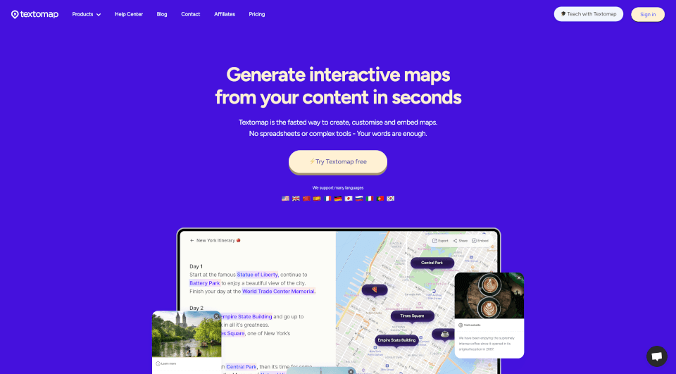
Textomap is an innovative tool designed to revolutionize how we create and manage interactive maps from text sources. With its user-friendly interface and powerful features, it allows users to transform location-based content into interactive maps in mere seconds, making it an essential tool for educators, content creators, travel agents, and more.
What are the features of Textomap?
-
Fast Map Creation: Textomap provides a lightning-fast solution for generating interactive maps directly from text. Simply input your content containing locations, and watch as Textomap assembles an engaging map in no time.
-
Mobile-Friendly Editing: No need to confine yourself to a desktop. Textomap allows for seamless map creation and editing on mobile browsers, offering flexibility and convenience for users on the go.
-
AI Integration: Using advanced artificial intelligence, Textomap assists users in generating content and extracting locations from text, making the mapping process even more efficient.
-
CSV Support: Users can easily upload CSV files with latitude and longitude coordinates to create extensive and detailed maps. This feature is particularly useful for data-driven projects.
-
Customizable Pins: Edit map pins with personalized colors, images, labels, and descriptions to enhance your map's visual appeal and informational value.
-
Embed and Share: Effortlessly embed your maps into websites or blog posts with simple copy-paste functionality. Sharing your interactive maps via links is just as straightforward.
-
Multi-Language Support: Textomap supports various languages, allowing users from different regions to create maps in their preferred language seamlessly.
What are the characteristics of Textomap?
Textomap stands out not just for its features but also for its characteristics:
-
User-centric Design: The platform is built with the user in mind, ensuring ease of use while providing powerful mapping capabilities.
-
Collaboration-Friendly: Textomap can be used by teams for collaborative projects, allowing multiple stakeholders to contribute to map creation.
-
Real-Time Updates: Maps created with Textomap reflect real-time changes, ensuring that all users have access to the latest information without the hassle of manual updates.
-
Integration Capabilities: Textomap can be integrated with popular platforms like WordPress, giving bloggers and webmasters an efficient way to enrich their content with interactive maps.
What are the use cases of Textomap?
Textomap finds its utility across a myriad of scenarios, including but not limited to:
-
Travel Itineraries: Create visually appealing travel itineraries that highlight destinations, attractions, and travel routes effectively.
-
Educational Tools: Educators can utilize Textomap to enhance geography or history lessons by creating interactive maps that illustrate significant locations and events.
-
Blog Posts: Content creators can elevate their blog posts with interactive maps related to travel, food, or lifestyle, making their articles more engaging and informative.
-
News Reports: Journalists can incorporate maps in news articles, visualizing key locations or events for a better reader understanding.
-
Event Planning: Create event maps detailing venues, attractions, and logistics to assist attendees in navigating large areas during conferences or festivals.
How to use Textomap?
To use Textomap effectively:
- Sign Up: Begin by signing up for a free account on Textomap’s website.
- Start a New Map: Select the type of map you want to create, whether from text or a CSV file.
- Input Your Data: Add your location-based text or upload a CSV that includes latitude and longitude.
- Customize: Edit pin colors, labels, and descriptions to suit your map’s theme.
- Embed or Share: Once satisfied, embed your map into your website or share it via social media with a generated link.
Textomap Pricing Information:
- Free Plan: Ideal for casual users, this plan allows for a limited number of maps with essential features.
- Pro Plan: For a modest subscription fee, users can access unlimited maps, advanced customization features, and additional tools.
